Distance: 3.45 Miles
Time: 1 hour 26 minutes
Dan and I decided to explore the 1442 acre lake in Webster, MA known as Lake Chargoggagoggmanchauggagoggchaubunagungamaugg whose popular translation is “You Fish on Your Side, I Fish on My Side, Nobody Fish in the Middle". This is the longest name of any lake in the US and was the gathering place for the Nipmuc Indians. I had kayaked on Webster Lake many times but today our exploration was focused particularly on checking out the North Village Bridge near Memorial Beach Park. I thought it would be a perfect time with the high water levels given the location of the bridge is mostly shallow swamp.
Some interesting statistics about the lake are that it is 1,442 acres, comprised of three spring-fed lakes joined by narrow channels, North Pond, Middle Pond and South Pond. There are 17 miles of shore line. The length of the lake is 3.25 miles, and at its widest point in Middle Pond, the distance is 1.125 miles. The shore line of North Pond is 5.78 miles, of Middle Pond, 7.06 miles, and South Pond is 4.17 miles.
Our path took us only 1.72 miles to the bridge and required us to travel from Sandy Cove, around Indian Point, through the narrows from Middle Pond to North Pond, across North Pond, around Second Island at Memorial Beach Park, and finally into Stump Pond. Stump Pond is a lily pad’s dream and we found ourselves paddling through many of them. Some were flowering and others past their prime. We saw all kinds of wildlife from Mallard ducks to Great Blue Herons. It was a peaceful paddle and we took our time and enjoyed the sites. Stump Pond is also where the old bridge found its new home.
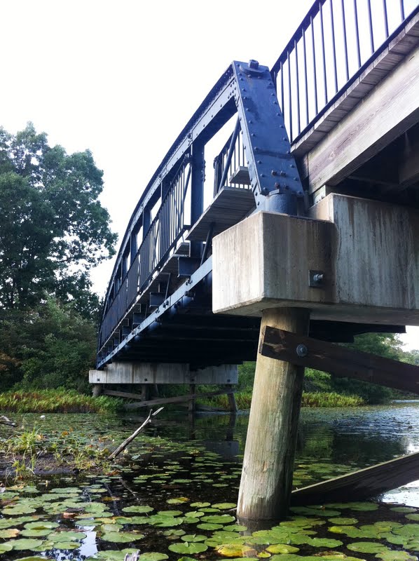
The North Village Bridge was originally built in 1871 to span French River. It connected North Main Street in Webster to Old Oxford Road in Dudley. It is 68ft long and 13ft wide. In 1998 the bridge was closed and schedule to be replaced. The original bridge was moved to Memorial Beach Park in 1999. It used to carry cars but today used as a pedestrian walkway. I had travelled over that bridge many times as a child with my parents on our way across town. It was interesting to see how small it was and I was happy to see this 140 year old bridge found a new home and a new purpose.
After taking a few pictures we began our trip back another 1.72 miles. The total trip was 3.45 miles and we completed it in a leisurely 1 hour and 26 minutes. I would have stayed out longer but we had dinner plans and we had gotten a late start after lunch. I also wanted to give the kayak’s a thorough cleaning since they have been barely used this season.
It was a great trip and reminded me why I bought my kayak. I am going to make it my goal to use it more before the end of the season.


No comments:
Post a Comment